Estimation Of Fire Hazards By Using Geo Spatial Technology Presentation
| Introduction | ||
|---|---|---|
| Estimation of fire hazards using geo spatial technology is an innovative approach to fire prevention and management. Geo spatial technology integrates geographic information systems (GIS) and remote sensing to analyze fire-prone areas. This presentation will explore the benefits and applications of using geo spatial technology for fire hazard estimation. | ||
| 1 | ||

| Understanding Fire Hazards | ||
|---|---|---|
| Fire hazards can be caused by various factors such as vegetation, climate conditions, and human activities. Geo spatial technology enables us to identify and map fire-prone areas based on these factors. By understanding fire hazards, we can develop effective prevention strategies and mitigate potential risks. | ||
| 2 | ||

| Mapping Vegetation Density | ||
|---|---|---|
| Vegetation density plays a crucial role in fire hazards as it determines the availability of fuel for fires. Geo spatial technology allows us to map and analyze vegetation density using satellite imagery and aerial photography. This information helps us identify areas with high vegetation density, which are more susceptible to fires. | ||
| 3 | ||

| Assessing Climate Conditions | ||
|---|---|---|
| Climate conditions, such as temperature, humidity, and wind speed, greatly influence the likelihood and spread of fires. Geo spatial technology enables us to collect and analyze climate data from weather stations and satellites. By assessing climate conditions, we can identify areas with high fire risk and predict fire behavior. | ||
| 4 | ||
| Identifying Human Activities | ||
|---|---|---|
| Human activities, such as urban development and land use changes, can increase fire hazards. Geo spatial technology allows us to track and monitor human activities through land cover mapping and change detection. By identifying areas with high human activity, we can implement targeted fire prevention measures. | ||
| 5 | ||
| Fire Risk Zonation | ||
|---|---|---|
| Geo spatial technology helps in creating fire risk zonation maps, which classify areas based on their vulnerability to fires. These maps provide valuable information for land use planning, emergency response, and resource allocation. Fire risk zonation facilitates effective mitigation strategies and enhances overall fire management. | ||
| 6 | ||

| Early Warning Systems | ||
|---|---|---|
| Geo spatial technology enables the development of early warning systems for fire hazards. By integrating real-time data from weather stations, satellite imagery, and ground sensors, we can detect potential fire risks. Early warning systems allow for timely evacuation, firefighting efforts, and resource mobilization. | ||
| 7 | ||

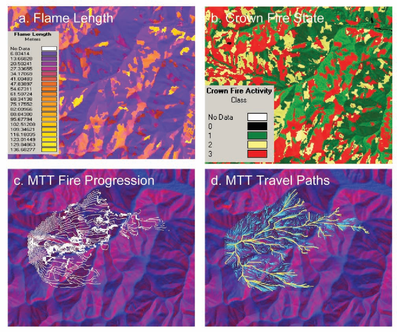
| Fire Modeling and Simulation | ||
|---|---|---|
| Geo spatial technology allows us to develop fire modeling and simulation tools. These tools simulate fire behavior, spread, and impact based on various factors such as topography and fuel load. Fire modeling and simulation assist in fire management planning, decision-making, and preparedness. | ||
| 8 | ||
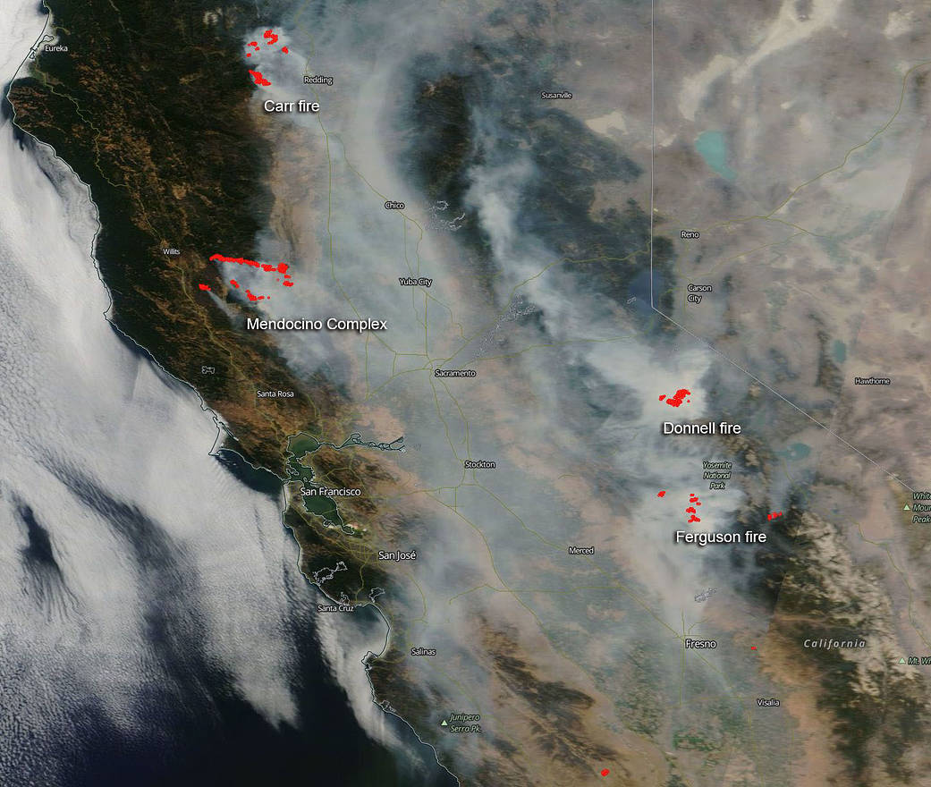
| Case Study: California Wildfires | ||
|---|---|---|
| The devastating California wildfires have showcased the importance of geo spatial technology in fire hazard estimation. By using GIS and remote sensing, experts have been able to analyze fire patterns, predict behavior, and improve response strategies. Geo spatial technology has played a crucial role in mitigating the impact of wildfires in California. | ||
| 9 | ||
| Conclusion | ||
|---|---|---|
| Estimation of fire hazards using geo spatial technology is essential for effective fire prevention and management. By mapping vegetation density, assessing climate conditions, and identifying human activities, we can identify fire-prone areas. Fire risk zonation, early warning systems, and fire modeling contribute to better preparedness, response, and mitigation. | ||
| 10 | ||
| References (download PPTX file for details) | ||
|---|---|---|
| Johnson, K. (2018). Geo spatial Technology fo... Zhou, X., & Li, W. (2019). A Review of Fire R... California Department of Forestry and Fire Pr... |  | |
| 11 | ||